Hiking in Iceland: Everything You Need to Know
Planning to hike in Iceland? This guide covers the best trails, how to prepare, when to go, what to pack, and what to expect en route.

Quick links
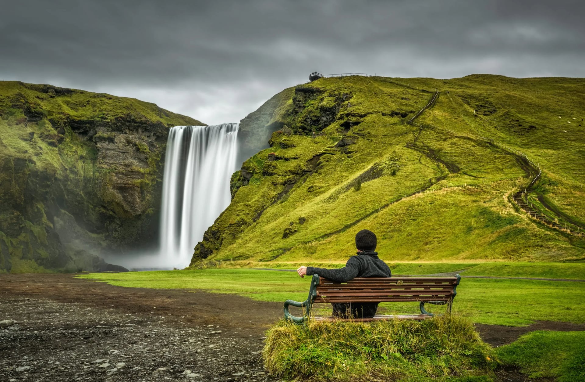
Iceland is one of the world's most distinctive hiking destinations — and for good reason. Few places on Earth pack volcanic plateaus, glacial rivers, geothermal fields, birch forests, and black sand coastlines into a single trail.
The season is short, running from late June to early September, but spectacular — and there is no better way to immerse oneself in Iceland's landscapes than on foot.
Why Hike in Iceland?
Iceland's hiking appeal really comes down to three things:
geological diversity,
well-developed infrastructure, and a
wide range of difficulty.
The landscapes are unlike anywhere else in Europe. You can walk from rhyolite mountains into obsidian deserts, cross glacial rivers on foot, pass geothermal hot springs, and descend into birch forests within a single multi-day route.
For such a wild landscape, the infrastructure is remarkably well developed. A network of mountain huts makes multi-day hiking accessible without camping, and scheduled buses from Reykjavík connect to all major trailheads.
As for difficulty, there is something for everyone. Short day hikes around Reykjavík suit casual walkers and families, while serious multi-day routes like the Laugavegur or Fimmvörðuháls will challenge even experienced trekkers.
You certainly don't need to be a mountaineer to hike in Iceland — though if you are, the country has plenty to offer you too.

Best Hiking Regions in Iceland
Iceland's hiking regions each have their own character. Here is a brief overview to help you decide on which region to focus.
Southern Region
Both the most varied and the most visited region, Iceland’s south is home to Iceland's best-known trails.
The Southern Highlands contain the classic hiking trail network: Laugavegur, Fimmvörðuháls, Þórsmörk, and Landmannalaugar. This region features volcanic terrain, geothermal activity, and glacier views.
The South Coast is lower altitude and more accessible, with a longer hiking season. Skógar, Reynisfjara, Vík, and the waterfall routes around Seljalandsfoss are all here. Our South Coast Highlights tour covers the best of this area.
Reykjanes, the peninsula that includes Keflavík Airport, has become geologically more active since 2021 — volcanic eruptions in the area have created new designated hiking trails. Awe-inspiring and genuinely unusual.
Eastern Region
Quieter and often underrated. The Víknaslóðir Trail ("Trail of the Deserted Inlets") takes you through puffin colonies, abandoned fishing settlements, and coastal ridgelines with almost no other hikers in sight.
Westfjords
The Westfjords are the wildest region of Iceland. Remote, dramatic, and home to Hornstrandir Nature Reserve — uninhabited, accessible only by boat, and one of the most challenging hiking areas in the country.
Northeastern Region
Volcanic landscapes around Lake Mývatn, the Askja caldera, and Krafla. Less visited than the south but geologically just as striking — expect moonscape terrain and active geothermal activity. Also home to Dettifoss, Europe's most powerful waterfall.

The Best Hiking Trails in Iceland
With hundreds of marked trails across the country, choosing where to walk can be the hardest part of planning a trip. These are some of the routes worth building a holiday around.
Multi-day hikes
1. Laugavegur Trail
Distance: 55 km | Duration: 4–5 days | Difficulty: Moderate
Iceland's most famous trail, running from the geothermal wonderland of Landmannalaugar to the green valley of Þórsmörk. Four days of rhyolite mountains, lava fields, river crossings, and glacial views. If you do one multi-day hike in Iceland, this is a great choice.
2. Fimmvörðuháls Trek
Distance: ~24 km | Duration: 2 days | Difficulty: Challenging
A high pass between two glaciers — Eyjafjallajökull and Mýrdalsjökull — with the Magni and Móði craters from the 2010 eruption at its highest point. The descent past more than 23 waterfalls to Skógafoss is one of the most dramatic stretches of trail in Iceland. Often combined with the Laugavegur into a single six-day route.
3. Hornstrandir (Westfjords)
Distance: Varies | Duration: 4–6 days | Difficulty: Challenging
Iceland's wildest trek — a nature reserve in the remote Westfjords, accessible by boat only, offering coastal cliffs, Arctic foxes, and near-total solitude. Best suited to experienced, self-sufficient hikers comfortable with camping and unpredictable weather.
4. Þórsmörk Glacier Valley
Duration: 4–5 days | Difficulty: Easy to challenging
Not a single trail but a valley full of them, sheltered between three glaciers in the Southern Highlands. Day hikes from Valahnúkur to the Tindfjöll Circle, plus connections to the Laugavegur and Fimmvörðuháls.
5. Kerlingarfjöll & Hveradalir
Distance: ~47 km | Duration: 3 days | Difficulty: Moderate to challenging
A cluster of orange rhyolite mountains in the Central Highlands, hiding one of Iceland's most spectacular geothermal areas — Hveradalir, a valley of steaming fumaroles, bubbling mud pools, and hot springs. The Hringbrautin Ring Route circles the massif with hut accommodation along the way — often called a quieter, higher-altitude alternative to Landmannalaugar.
6. Víknaslóðir Trail
Distance: ~50 km | Duration: 4 days | Difficulty: Moderate
East Iceland's coastal classic — puffins, fjords, abandoned fishing settlements, and almost no crowds. A quieter, more atmospheric alternative to the Laugavegur.
Day Hikes
Worth knowing for shorter adventures or rest days:
Reykjadalur Hot Springs — 2–3 hours, close to Reykjavík, ends in a geothermal river you can bathe in
Glymur Waterfall — 4–5 hours to Iceland's second-highest waterfall, includes a river crossing
Mount Esja — 3–5 hours on the mountain that looms over Reykjavík, easy access by bus
Landmannalaugar day loops — several options from the Laugavegur trailhead, including the Bláhnúkúr–Brennisteinsalda loop through rhyolite peaks
Prefer a comprehensive list? You can find all hiking routes in Iceland listed on the Ferðamálastofa Iceland Tourist Board website.

Accommodation: The Icelandic Hut System
Iceland's multi-day trails are built around a network of mountain huts (fjallakofi in Icelandic), managed primarily by Ferðafélag Íslands — FÍ (Icelandic Touring Association). FÍ operates around 40 huts across the country, including all the major huts on the Laugavegur and Fimmvörðuháls trails.
For more in-depth information read our guide on Iceland’s mountain huts.
What to Expect
Huts are basic, but comfortable.
Facilities typically include:
Dormitory-style bunk beds with mattresses (sleeping bag required)
Communal kitchen with basic cooking facilities
Shared toilets (sometimes outdoor)
Drying rooms for wet gear
Showers at some locations, usually for a small fee
Larger huts in popular locations (Landmannalaugar, Þórsmörk) tend to offer more amenities than smaller, remote huts. Pack your own toilet paper (a ziplock bag helps) to use wherever toilet paper is not available.
Only a few huts in larger complexes, like Volcano Huts in Húsadalur, have on-site restaurants. However, most huts do not serve meals — bring your own food with you, if that’s the case for your chosen hut. Dehydrated meals, oats, nuts, cheese, chocolate, and energy bars are standard. It is best to buy supplies in Reykjavík before heading out.
Before you book, check if and when the hut is manned or not on FÍ‘s official page or other. If it is, check in with the warden upon arrival — they will confirm your booking and tell you where to sleep.
Hut Etiquette
Mountain huts in Iceland operate on a kind of informal code — part tradition, part common sense. FÍ has a set of simple rules published, but the ones most worth knowing are:
Check-in and check-out times. Check-in runs 12:00–20:00, and you should be out by 10:00 the following morning.
Quiet hours are 0:00 AM to 7:00 AM — even under the midnight sun.
Pack out your rubbish. Most huts have no waste bins; carry everything back down to the lowlands.
No shoes inside — universally applicable for all Icelandic huts.
Check in with the warden if one is on site — they'll confirm your booking and tell you where to sleep.
When to Book
Advance booking is essential, especially in peak season:
July hut beds on the Laugavegur can sell out within hours of reservations opening — as early as January
August dates typically fill by March or April
Camping next to huts rarely requires advance booking, but camping guests cannot use the kitchen facilities.
Last, but not the least - not every Iceland hike requires huts. For day-hike-based tours, some hikers use hotels and guesthouses, giving a more comfortable alternative for those who prefer it.

The Weather
Iceland's hiking season runs late June through early September, and daily weather is the single biggest variable on any trip.
Two things to know up front:
Thunderstorms are extremely rare in Iceland — almost unheard of in summer — so the "see lightning, get off the ridge" rule you live by in the Alps doesn't really apply here.
The classic Alpine "turn-back" triggers — a thunderstorm forecast, an avalanche level — barely apply in Iceland. The conditions that close out a hiking day here look different, but they are every bit as serious.
The main hazards:
Wind is perhaps the most underestimated element of hiking in Iceland. Sustained 54–72 km/h (15–20 m/s) gusts on exposed passes are routine in July and August; 90 km/h (25 m/s) is plausible in any summer month.
Wind is not correlated with temperature, and not always predicted by lowland forecast. Gust forecasts are more important than wind averages.
Iceland's highlands are fully exposed to severe conditions. Sunshine can turn to wind and rain within minutes. Pack waterproof and windproof outer layers plus thermal base layers regardless of the forecast.
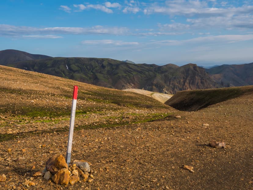
A summer day on the Hrafntinnusker plateau can sit at 3–5 °C with horizontal rain. Visibility on stake-marked saddles (Fimmvörðuháls, the upper Laugavegur) can drop to 20 meters.
Wet snow is possible at altitude in any month. Fimmvörðuháls and other high passes hold névé into mid-July and can take fresh snow in August.
Warm sunny days melt the icecaps faster, raising afternoon flow on rivers like Þröngá, Krossá, and the unbridged Bláfjallakvísl. Water is highest in late afternoon, lowest in early morning.
For advice on how to act in case of extreme weather on trail, read this helpful hikers' survival guide.
When NOT to head out:
The Icelandic Met Office issues color-coded warnings — yellow, orange, red. Treat orange like the Alps treat a thunderstorm forecast: change your plan, don't push it. Red means stay in the hut, full stop.
Wind forecast above 18 m/s (65 km/h) on an exposed pass — turn back or wait it out. This is the single most useful threshold to keep in mind.
Cold rain plus temperatures below 5 °C on a long exposed leg — high hypothermia risk even with good gear. Wait for a window.
A storm (óveður) warning in the local forecast — stay put. The hut warden will usually tell you directly.
Iceland’s hiking trails include a continuous risk gradient — wind, temperature, visibility, and river flow all factor in, and waterproofs alone are sometimes not enough. Build at least one wait day into any solo or multi-day itinerary for exactly this reason.
On staffed routes, the hut wardens’ read on the next leg is often as reliable as any app.
For a full breakdown of Iceland's weather by month, see our respective monthly guides.

On the Trail
What are Iceland’s Trails Like?
No technical scrambling, but smooth, wide paths are not common either
Good weather is never guaranteed, regardless of the season
Assume your feet will get wet at some point, either while crossing rivers or getting caught in the rain.
Very windy, especially on ridgelines
Laugavegur Trail can be very busy, especially in July.
Navigation
Major trails like the Laugavegur are well marked, but weather can reduce visibility rapidly. Some sections (particularly the Tindfjöll Circle in Þórsmörk) have gaps in waymarking.
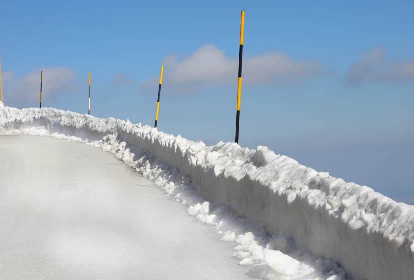
Trail markings in Iceland
Iceland does not have a nationally standardized trail-marking system the way the Alps or Scandinavia do. With almost no trees to paint, the system largely relies on other methods. Quality varies by trail, region, and the body that maintains it, and it drops sharply the moment you leave the most-walked routes.
What you'll typically see on Icelandic hiking trails:
Many stakes are removed, snowed under, or blown down between mid-September and June.
What this means in practice:
On the most popular and well-marked trails — Laugavegur, Fimmvörðuháls in clear weather, day hikes from Þórsmörk or Skaftafell — the stakes alone are enough.
On every other trail, carry a GPS-loaded route on your phone or device (on our tours, we provide them for you), plus a paper backup map. Mobile signal isn't reliable in the highlands. The standard topographic series is published by Landmælingar Íslands (the National Land Survey) and is available through most hiking apps.
In low visibility, even the best-marked saddles become a stake-to-stake scramble. If you cannot see the next stake, stop and reassess. Do not push on by guess.
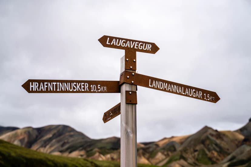
How to Read Icelandic Place Names
Icelandic place names are unusually literal and consistent — once you know a few common endings, you can often understand the terrain directly from the map or signpost.
Here’s a short reading key for the names you'll see most often on your path in Iceland.
-jökull — glacier (Vatnajökull)
-fjall / -fjöll — mountain / mountains. (Tindfjöll)
-fell — a smaller, rounded mountain or hill. (Skaftafell)
-dalur — valley. (Reykjadalur)
-gljúfur — canyon, gorge. (Jökulsárgljúfur)
-foss — waterfall (Dettifoss)
-á — river. (Krossá, Jökulsá)
-vatn — water; lake in place names. (Álftavatn)
-laug / -laugar — warm pool / pools. (Landmannalaugar)
-nes — peninsula, headland. (Snæfellsnes)
-ey / -eyjar — island / islands. (Vestmannaeyjar)

River Crossing
Unbridged glacial river crossings are part of hiking on routes like the Laugavegur and Fimmvörðuháls. Early-season rivers run fast and high from snowmelt; by August they are far more manageable.
Basic technique: unbuckle your pack's hip belt before entering (so you can shed it if you fall), use trekking poles for stability, cross at the widest/shallowest point, and never attempt fast-moving thigh-high water alone. Lightweight water shoes protect your feet from the cold, rocky riverbeds.
If a crossing looks dangerous, turn back or wait — glacial rivers drop significantly between morning and afternoon on warm days.
Midges
Though usually associated with the British Isles, they are also present in Iceland, especially around Lake Mývatn in July and August. Much less of an issue on the Laugavegur and Fimmvörðuháls than in the north. A head net is worth packing if you're hiking near Mývatn. You can read more tips and tricks to survive these in this blogpost on midges.
Arctic Terns
Arctic Terns are small, slender migratory seabirds that become aggressively territorial during nesting season (May–August). They will dive-bomb hikers who come near their nests. Wave a stick above your head to redirect them — this is standard Icelandic trail knowledge.
Protect the Environment
Iceland takes Leave No Trace seriously:
Never leave the marked trails — off-trail walking damages fragile moss that can take centuries to recover
No open fires permitted anywhere in the highlands
Pack out everything, including toilet paper
Respect wildlife — observe from a distance, don't feed anything
Register Your Route
Iceland is a well-established hiking destination with reliable infrastructure, clearly marked trails, and a long safety record. That said, sensible preparation and respect for the conditions are essential. Iceland's mountain rescue service (Landsbjörg) asks all hikers to register their route before setting out. Use the free Safe Travel registry — this is how rescuers find you faster if something goes wrong in the highlands.
Emergency Information
Local emergency number: 112 — Iceland's universal emergency number, with a free 112 Iceland app that lets rescuers locate you via GPS. Mobile signal is unreliable on highland trails — carry a fully charged phone, but don't depend on it.

How to Plan Your Iceland Hike
When to Go
The best time to hike in Iceland is from late June to early September, with July and August offering the most reliable conditions. August tends to strike the best balance between stable weather and thinning crowds.
Outside this window, highland trails are largely inaccessible — snow, closed huts, and dangerous river levels make multi-day treks unsafe for all but the most experienced mountaineers. Coastal routes in the south remain accessible from late May until the end of September.
For a full month-by-month breakdown, see our dedicated guide on the best time to hike in Iceland.
Getting Around
Most highland hiking in Iceland is organized around Reykjavík as a hub. The capital's BSÍ Bus Terminal is the main departure point for scheduled buses to all the major trailheads — Landmannalaugar, Þórsmörk, and Skógar among them.
There are no direct bus services between trailheads, which means most multi-day hikes start and end with a return trip through Reykjavík. From Keflavík Airport, the Flybus shuttle connects to Reykjavík in about 45 minutes.

Iceland's road system splits into three broad categories worth knowing before you plan:
The Ring Road (Route 1) circles the entire country and is fully paved. This is the main artery, and most South Coast hiking trailheads sit on or just off it.
Paved secondary roads cover most other routes near populated areas — fine for any rental car.
Gravel roads are common once you leave main routes. Drivable in a standard car but slower, and you'll want to watch for loose stones on windshields.
F-roads (Fjallvegir — "mountain roads") are the designated highland roads, legally restricted to 4×4 vehicles only. They are rough, gravel, often cross unbridged rivers, and close completely outside summer (roughly late June to early September). Many F-roads include sections that require genuine 4×4 capability and experience.
For highland trailheads, driving yourself is rarely an option — most rental companies prohibit their vehicles on F-roads and no insurance in Iceland covers water damage from river crossings. The scheduled bus network is almost always simpler, safer, and cheaper.
Mobile coverage is reliable on the Ring Road, patchy on F-roads, and unreliable on highland trails — carry a charged phone but don't depend on it.
With or Without a Guide
Both approaches work well in Iceland.
Our hiking tours in Iceland are self-guided. You walk at your own pace, on your own schedule — but huts, transfers, and route navigation are handled for you, along with 24/7 support while you're on trail. It is the approach that suits most hikers: the independence of hiking on your own terms with the more complex logistics taken care of.
What to Pack
The essentials:
Waterproof shell jacket and pants
Insulating mid-layer (fleece or light down)
Thermal base layers
Warm hat and gloves
Hiking socks
Waterproof hiking boots, properly broken in
Lightweight water shoes for river crossings (essential on trails like Laugavegur)
35–50 litre backpack
Trekking poles
Headlamp
Sleep mask
Water bottle or hydration pack
First aid kit
Sunglasses and sunscreen
Sleeping bag (huts provide mattresses but no bedding; the interior is heated and gets warm when crowded, but also loses heat fast when aired or if the hut runs empty; consider a comfort rating of 0°C to -5°C)
Light hut shoes or sandals
Pack weight target: 8–12 kg for a multi-day hike. Every extra kilogram is felt after day one. The most common first-timer mistake is packing too many "just in case" items.
See the full packing list and more in-depth information on recommended gear in our Iceland hiking gear guide.

Know Before You Arrive
Here's a comprehensive list of everything important to know before your trip to Iceland:
Money & Costs
Iceland is expensive. Realistic expectations*:
Hut beds: 15,800 ISK / ~€105 / ~$115 per person per night
Bus transfers: ~14,900 ISK / ~€100 / ~$110 one way Reykjavík ↔ Landmannalaugar or Þórsmörk
Food for a week: €100–150 / ~$110–165 if you buy in Reykjavík supermarkets (Bónus and Krónan)
Card payments accepted almost everywhere; cash rarely needed
Tipping is not expected
The good news is that prices for FÍ mountain huts and highland buses remain fixed throughout the hiking season. What fluctuates seasonally is standard accommodation (hotels, Airbnb, hostels), flights, and car rental. Some tours and excursions may offer shoulder-season specials.
Multi-day hiking with hut accommodation works out far cheaper than hotel-based travel — one of the genuine upsides of this style of trip.
*Prices verified April 2026. FÍ huts and highland buses adjust their rates annually; check respective websites for current figures.
SIM cards & connectivity
Mobile coverage is patchy on highland trails — don't rely on it for navigation
eSIM options work well and are easy to activate on arrival
Drinking Water
Iceland's tap water is exceptional quality — drink straight from the tap everywhere. The hot tap water may smell of sulfur (in most areas, it is sourced from geothermal springs), and is not recommended for drinking.

Best Sources of Information
A handful of official Icelandic websites are worth bookmarking before your trip — they're the most reliable sources for conditions on the day you hike.
Weather: the Icelandic Met Office, with specialised highland forecasts and wind gust predictions
Road conditions: IRCA (Icelandic Road and Coastal Administration) — live updates on F-road openings and closures, updated daily in season
Safe Travel — register your hiking route, read packing lists, safety tips, crucial information and receive real-time safety alerts from Icelandic mountain rescue
Trail and hut bookings: Ferðafélag Íslands, operators of most mountain huts on the Laugavegur and other trails
National parks maps: Environment Agency of Iceland, with rules and maps for Hornstrandir and other protected areas
Ready to Plan Your Iceland Hike?
Iceland rewards those who plan well and pack smart — and we're here to help with both.
Browse our self-guided Iceland hiking tours or get in touch, and we'll help you match the right trail to your experience, travel dates, and fitness level. Every hut booking, bus transfer, and route note is handled, so you can focus on the walking.


HASSLE FREE
We handle itineraries, accommodations, and anything else you prefer not to deal with, so you can enjoy a carefree hike.

BOOK WITH CONFIDENCE
We are a financially protected company, fully bonded and insured, keeping your money safe and allowing you to travel with confidence.

TRIED & TESTED ADVENTURES
Only the best hut to hut hikes in the USA, cherry-picked by our local team with an in-depth knowledge of the region.

UNBEATABLE SUPPORT
Our 24/7 customer support is where we show our passion, bringing you a better experience by making your well-being our number one priority.